Sands of Time: White Sands, Big Skies

©2018 Thomas Dodge
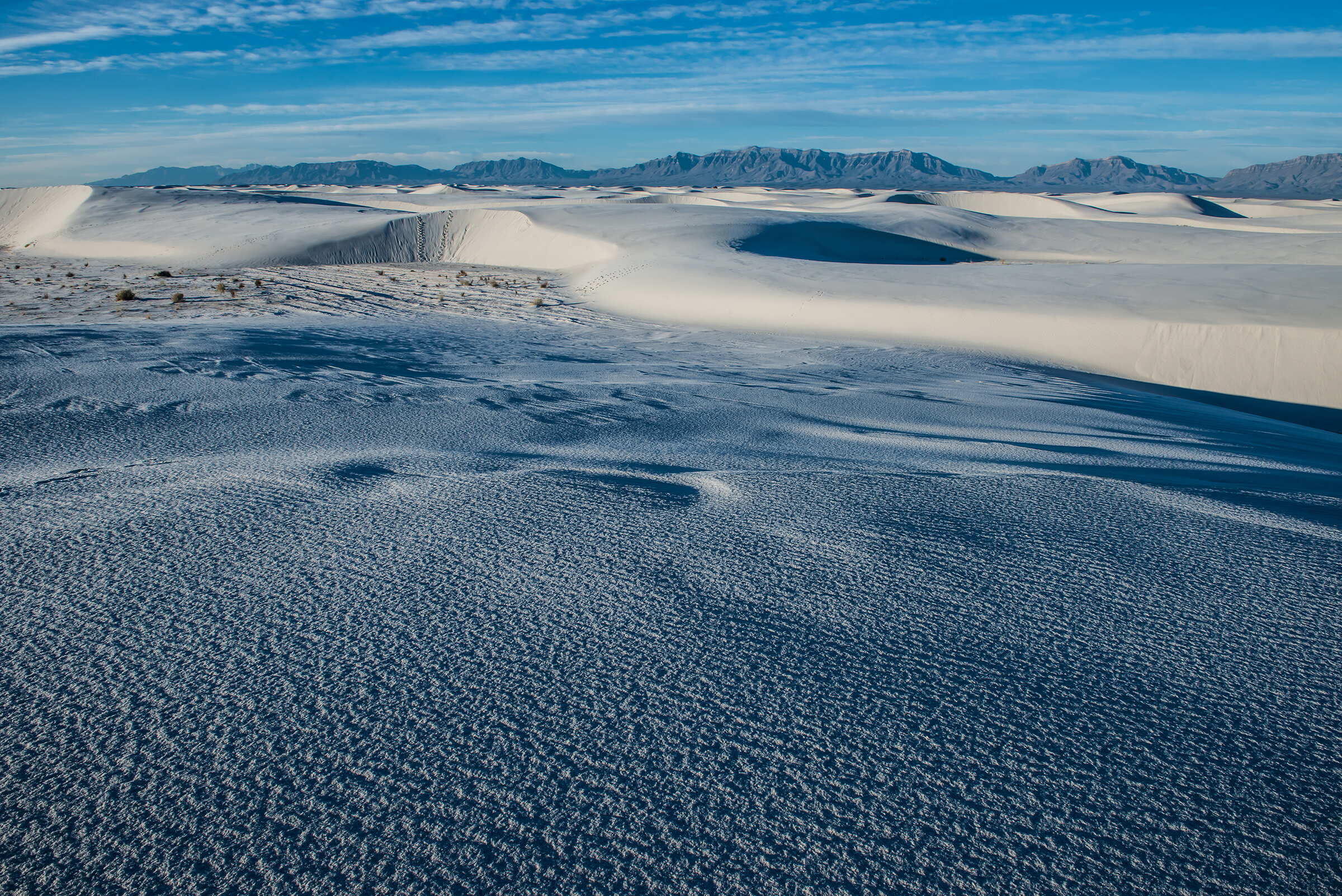
From dawn to dusk, the 275-square-mile dunefield of southern New Mexico’s White Sands National Monument is ever changing, just as its shimmering, sifting gypsum sands have ever changed every day for eons.
While White Sands National Monument preserves the world’s largest gypsum sand dunefield, it is nearly encompassed by the much larger desert expanse of the U.S. Army’s White Sands Missile Range. The range, the largest land-based military reservation in the country, is operated as a proving ground where some 900 missiles are fired for testing every year. Tourists to the national monument are forewarned and prohibited from entering the park when missile testing occurs nearby. Trailhead signs ominously warn hikers not to touch any foreign objects they may find in their path.
On a cold January morning, my photo assistant, Jon, and I entered the park at sunup. Apparently there were no bombing missions scheduled for this day. The morning ground fog wafted over the dunes giving this place a prehistoric feel. With hardly another soul in the park, and no one to be seen, we were alone in the white fog on white sand. It surely could’ve been the Ice Age.
In time, the fog gradually lifted and the Southwestern sun began to pierce through and light the ivory dunes. As the fog dissipated, light shimmered off the grains of gypsum against the deep-blue, high desert sky. With tripod and bags of equipment on our backs we headed down the meandering Alkali Trail. Yesterday’s footprints were ghosted over with newly sifted sand.
Everywhere we turned to look, every hill we climbed, was a fresh, abstract spectacle of the play of shadow, light and color. It is one of those places where every angle is a beautiful picture, where you start shooting like there’s no tomorrow. Until you realize, not only is there tomorrow, but there still is the rest of this early day. My advice: bring plenty of memory cards—this place is a visceral thrill for any photographer. And, as the sharp early light fades into mid-day brightness, we settle into the ancient rhythm of the winter light. We settle down and, instead of shooting everything we see, we start to see everything.
White Sands is the heart of the Tularosa Basin, which lies in the northern reaches of the high Chihuahuan Desert. Anchored by the town of Alamogordo, home to Holloman Air Force Base, the basin is surrounded by desert mountains, formed as the Permian Sea retreated millions of years ago. From those mountains during the last Ice Age, 24,000 to 12,000 years ago, rain and snowmelt carried gypsum runoff down to the basin to enormous Lake Otero. The lake began to evaporate as the Ice Age ended and in its newly dry lakebed were large pockets of the crystalline form of gypsum called selenite.
Otero disappeared and left today’s playas—ephemeral Lake Lucero and Alkali Flat—formed some 10,000 years ago and still holding water for a time during the desert’s wettest years. Steady winds at the end of the Ice Age scraped off the exposed lakebeds to expose the gypsum crystals, which gradually decomposed into the gypsum sand that formed the dunes. Lake Lucero lies on the southwest edge of White Sands National Monument and the prevailing southwest winds swept the gypsum into the large dunefield, a process that continues to form new dunes today.
The National Park Service, which oversees the national monument, has compiled a list of interesting facts about gypsum and its myriad uses:
• The five basic forms of gypsum in the world are selenite, satin spar, alabaster, rock gypsum and gypsite;
• Dehydrated gypsum results in plaster of Paris (named for the largest gypsum deposit in The City of Light). Benjamin Franklin introduced gypsum to the United States after seeing it in France;
• Gypsum was used for sculpture (still is!) by ancient Greeks, Assyrians and Chinese, and was first used in construction as mortar for the Egyptian Pyramids of Cheops. Its most common use in the United States today is in drywall;
• Not only is it used in the manufacture of medicine, insecticide, paint, soil fertilizers and crayons, but it is used in some beers, tofu, baked goods and frozen desserts;
• In 2004, the Mars Rover confirmed gypsum dunefields on Mars, and because the formation of gypsum is associated with water, its discovery there has led to the speculation of the possibility of life on Mars;
• Because gypsum is so heavy (therefore expensive) to transport, and because White Sands historically is so remote, the mining of these dunes of the national monument was never practical.
White Sands National Monument is all about the preservation of the flora and fauna of these dunes as well as the preservation of traces of Archaic tribes that lived here and farmed on the arable edges of the dunes. Of course, the first humans here were hunters and gathers, the Paleo-Indian of 8,000 to 12,000 years ago and, later, the people of the Archaic Period (6,000 BC to 200 AD).
The Jornada Mogollon followed leaving the first traces of pottery and permanent living structures. They harvested the wild Indian ricegrass, a wheat-like plant, but actually farmed the “three sisters:” maize, beans and squash. By 1350 AD, like so many of the Puebloan people of the time, the Jornada Mogollon simply disappeared. Whether drought or pestilence was the cause is still uncertain, but anthropologists believe the ancient Puebloans blended into other peoples still extant throughout the Southwest.
Perhaps the most striking evidence of ancient human existence found here is in the “hearth mounds” from the Archaic period, which have been molded into the dunes for eternity. These contain the charcoal and ash remnants of prehistoric fires. Frozen in time, the “glazed”-over hearths remain as a result of the chemical reaction among gypsum, moisture and heat.
The hunting and gathering Apachean people arrived here in the mid-1400s and lived peaceably among themselves until the arrival of Spanish Colonial explorers a hundred years later and then Anglo and Hispanic settlers who were intent on taking some of the Apachean strongholds for their own agricultural use in the mid-1800s. Those full-out wars across the West became the fodder of famous Hollywood Westerns, many of them filmed right here in New Mexico. These skirmishes have continued into modern times in places such as South Dakota’s Wounded Knee and most recently, North Dakota’s Standing Rock.
The Native American struggle to hold onto hallowed ground continues today as the Federal government seeks to rescind lands recently established as national monuments, particularly, Utah’s Bears Ears and Grand Staircase Escalante National Monuments. Rather than protect native spiritual heritage and traditions, the government would like to take over these lands and hire them out to corporations for mining, fracking rights and to ranchers for grazing rights.
As one of the granddaddies of the national monument system, established in 1936, White Sands largely is protected from such usurpation. In fact, a coalition of local governments and New Mexico’s two senators are pushing hard to give the national monument designation as a National Park. Since parks tend to have a higher profile than monuments, this could lead to a huge boost in tourism.
As is, a recent National Park Service report documents that White Sands in 2016 attracted 555,800 visitors. These tourists supported 437 jobs throughout the Tularosa Basin by spending $29.3 million. The report says the cumulative effect of monument-related spending totaled $33.6 million—the bulk of it being from people outside the region, not local dollars being recirculated. As a representative for U.S. Senator Martin Heinrich (D-NM) said: it is “an economist’s dream.”
The monument’s dunefield seems bizarre yet at the same time paradisiacal. But as your reverie is intermittently interrupted by sorties of fighter jet maneuvers from nearby Holloman, you are reminded of the dark secret that occurred near here on a July morning in 1945. Some 70 miles north in the White Sands Missile Range stands a monument known as the Trinity Site, at Ground Zero, where on July 16, 1945, (one week after the U.S. government established White Sands Missile Range) the first atomic bomb, called “The Gadget,” was successfully detonated.
The range, today still used as a proving ground by the military and adjacent to Holloman Air Force Base, stands testament to Project Trinity, arguably the mid-Twentieth Century’s major—and horrific—human achievement. The 100-foot steel tower, atop of which sat The Gadget, was vaporized by the explosion. The ensuing multi-colored mushroom cloud rose 38,000 feet in seven minutes. The brilliant, blinding blast left a crater a half-mile in diameter and eight feet deep. The sand in the crater fused into a glass-like jade green and was named trinitite. Awed by what they saw, what they had created, the Manhattan Project scientists hooted and hollered—and then were stunned into stony silence.
New Mexico writer, Frank Waters, describes in his novel “The Woman At Otowi Crossing,” the sight that his character, a Manhattan Project scientist named Gaylord, saw through his dark goggles:
“What he saw through them was at once beautiful and terrifying. A huge, searing ball of fire brighter than the midday sun. It was boiling violently, swiftly expanding in size, and slowly, majestically rising straight into the sky. Changing in color from livid red to yellow, gray, blue and purple.”
An inscription by Manhattan Project leader, J. Robert Oppenheimer, loomed over an exhibition about the project, called “Boom,” at the New Mexico History Museum in Santa Fe in 2018. Oppenheimer wrote in 1965: “We knew the world would not be the same. A few people laughed, a few people cried. Most people were silent.”
That August, the world’s second atomic bomb, a uranium-based bomb nicknamed “Little Boy,” was dropped on Hiroshima while the third, “Fat Man,” obliterated Nagasaki a few days later. Both “Gadget” and “Fat Man” were plutonium-based bombs. To be fair, most remaining members of “The Greatest Generation,” will tell you that the development of the atomic bomb at the secret city of Los Alamos on the Pajarito Plateau of northern New Mexico, certainly shortened World War II. But at what cost did the atomic age dawn?
It was the ever-changing natural light of the sun that Jon and I chased through the day. Despite the atomic heritage not far away, White Sands National Monument remains a natural wonder geologically, complete with a surprisingly rich and unique population of flora and fauna. There is water just below the dunes and in some places, where the dunes have sifted away, small bodies of wetlands can appear for a time.
Some 220 species of birds, from hummingbirds to ravens, roadrunners to wrens to owls, migrate through the monument over the course of a year. Some, like the hearty cactus wren, are year-round residents. While the summer heat of the dunefield keeps most species in the surrounding desert scrub, the cactus wren and the horned lark (to name two) will occupy the dunes, as well, throughout the seasons.
Several “white species” of animals have adapted specifically to the White Sands dunes, lighter in color than their “cousins” living only a few short miles away. These include Apache pocket mouse, bleached earless lizard, sand-treader camel cricket, sand wolf spider, while the white moth (among 40 species of moth endemic to White Sands) lives nowhere else on earth.
As for plants and flowers, the usual desert suspects can be found along the dune edges and in the interdunal areas. These include the aforementioned indian ricegrass, cacti and desert succulents of all species, alkali sacaton, little bluestem. Ubiquitous trees and plants here are creosote, mesquite, Mormon tea, skunkbush sumac, among others. The presence of Rio Grand cottonwood indicates the presence of water beneath the dunes.
For as fascinating as the flora and fauna here may be, we came to photograph the ever sifting abstract forms of the white dune landscape. Even on a January afternoon, the heat off these dunes can begin to feel somewhat oppressive. But as the sun settles behind the western San Andres Mountains, a cool blue settles over the dunefield. Back on the Alkali Trail we met up with a park official we named “Ranger Rick,” whose job at this hour it was to clear day hikers out of the park. A friendly man with an encyclopedic knowledge of the national monument, he invited us back and encouraged us to obtain a camping permit sometime to see how the dunes glisten on a full moon night.
SOJOURN STATS
US Highway 70 brings you to the entrance to White Sands National Monument, 15 miles south of Alamogordo and 54 miles west of Las Cruces. On any given day, sections of Highway 70 may be closed for a couple of hours due to bombing missions in the vicinity.
The visitor’s center is the only place in the park to get water and features exhibits, a bookstore and a gift shop with some concessions. Here you may get information on park programs and ranger-led activities. Overnight camping permits may be purchased here (or online at www.nps.gov/whsa).
Dunes Drive is the only road in and out of the national monument and from which start all trails, including an accessible dune boardwalk trail. Several picnic areas with shelters, grills and restrooms are located along Dunes Drive. There is no potable water available inside the national monument.
Area lodging and camping may be found in Alamogordo, Las Cruces and the surrounding area.
(Editor’s note: Much of the information for this article came courtesy of the National Park Service. See more in detail about White Sands at www.nps.gov/whsa.)