

Essays
This section of the site is for those of you who like “long reads.” I’ll be adding new essays as I write them, but for today I offer you two essays: “White Sands, Big Skies” and “Rocks of Ages.”
“White Sands, Big Skies” will be published in book form with an expanded portfolio of images later in 2022.

Sands of Time: White Sands, Big Skies
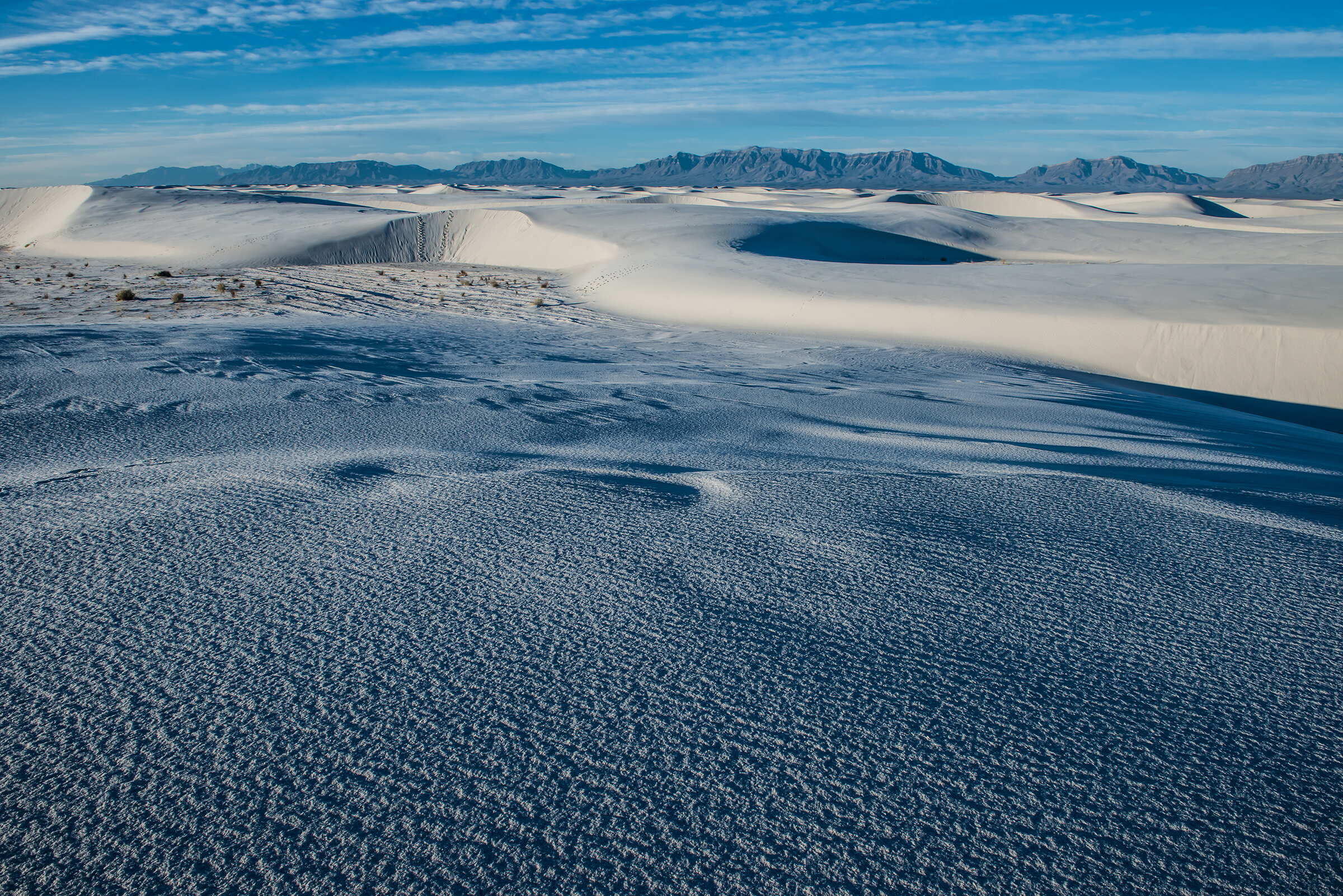
From dawn to dusk, the 275-square-mile dunefield of southern New Mexico’s White Sands National Monument is ever changing, just as its shimmering, sifting gypsum sands have ever changed every day for eons.

©2018 Thomas Dodge
From dawn to dusk, the 275-square-mile dunefield of southern New Mexico’s White Sands National Monument is ever changing, just as its shimmering, sifting gypsum sands have ever changed every day for eons.
While White Sands National Monument preserves the world’s largest gypsum sand dunefield, it is nearly encompassed by the much larger desert expanse of the U.S. Army’s White Sands Missile Range. The range, the largest land-based military reservation in the country, is operated as a proving ground where some 900 missiles are fired for testing every year. Tourists to the national monument are forewarned and prohibited from entering the park when missile testing occurs nearby. Trailhead signs ominously warn hikers not to touch any foreign objects they may find in their path.
On a cold January morning, my photo assistant, Jon, and I entered the park at sunup. Apparently there were no bombing missions scheduled for this day. The morning ground fog wafted over the dunes giving this place a prehistoric feel. With hardly another soul in the park, and no one to be seen, we were alone in the white fog on white sand. It surely could’ve been the Ice Age.
In time, the fog gradually lifted and the Southwestern sun began to pierce through and light the ivory dunes. As the fog dissipated, light shimmered off the grains of gypsum against the deep-blue, high desert sky. With tripod and bags of equipment on our backs we headed down the meandering Alkali Trail. Yesterday’s footprints were ghosted over with newly sifted sand.
Everywhere we turned to look, every hill we climbed, was a fresh, abstract spectacle of the play of shadow, light and color. It is one of those places where every angle is a beautiful picture, where you start shooting like there’s no tomorrow. Until you realize, not only is there tomorrow, but there still is the rest of this early day. My advice: bring plenty of memory cards—this place is a visceral thrill for any photographer. And, as the sharp early light fades into mid-day brightness, we settle into the ancient rhythm of the winter light. We settle down and, instead of shooting everything we see, we start to see everything.
White Sands is the heart of the Tularosa Basin, which lies in the northern reaches of the high Chihuahuan Desert. Anchored by the town of Alamogordo, home to Holloman Air Force Base, the basin is surrounded by desert mountains, formed as the Permian Sea retreated millions of years ago. From those mountains during the last Ice Age, 24,000 to 12,000 years ago, rain and snowmelt carried gypsum runoff down to the basin to enormous Lake Otero. The lake began to evaporate as the Ice Age ended and in its newly dry lakebed were large pockets of the crystalline form of gypsum called selenite.
Otero disappeared and left today’s playas—ephemeral Lake Lucero and Alkali Flat—formed some 10,000 years ago and still holding water for a time during the desert’s wettest years. Steady winds at the end of the Ice Age scraped off the exposed lakebeds to expose the gypsum crystals, which gradually decomposed into the gypsum sand that formed the dunes. Lake Lucero lies on the southwest edge of White Sands National Monument and the prevailing southwest winds swept the gypsum into the large dunefield, a process that continues to form new dunes today.
The National Park Service, which oversees the national monument, has compiled a list of interesting facts about gypsum and its myriad uses:
• The five basic forms of gypsum in the world are selenite, satin spar, alabaster, rock gypsum and gypsite;
• Dehydrated gypsum results in plaster of Paris (named for the largest gypsum deposit in The City of Light). Benjamin Franklin introduced gypsum to the United States after seeing it in France;
• Gypsum was used for sculpture (still is!) by ancient Greeks, Assyrians and Chinese, and was first used in construction as mortar for the Egyptian Pyramids of Cheops. Its most common use in the United States today is in drywall;
• Not only is it used in the manufacture of medicine, insecticide, paint, soil fertilizers and crayons, but it is used in some beers, tofu, baked goods and frozen desserts;
• In 2004, the Mars Rover confirmed gypsum dunefields on Mars, and because the formation of gypsum is associated with water, its discovery there has led to the speculation of the possibility of life on Mars;
• Because gypsum is so heavy (therefore expensive) to transport, and because White Sands historically is so remote, the mining of these dunes of the national monument was never practical.
White Sands National Monument is all about the preservation of the flora and fauna of these dunes as well as the preservation of traces of Archaic tribes that lived here and farmed on the arable edges of the dunes. Of course, the first humans here were hunters and gathers, the Paleo-Indian of 8,000 to 12,000 years ago and, later, the people of the Archaic Period (6,000 BC to 200 AD).
The Jornada Mogollon followed leaving the first traces of pottery and permanent living structures. They harvested the wild Indian ricegrass, a wheat-like plant, but actually farmed the “three sisters:” maize, beans and squash. By 1350 AD, like so many of the Puebloan people of the time, the Jornada Mogollon simply disappeared. Whether drought or pestilence was the cause is still uncertain, but anthropologists believe the ancient Puebloans blended into other peoples still extant throughout the Southwest.
Perhaps the most striking evidence of ancient human existence found here is in the “hearth mounds” from the Archaic period, which have been molded into the dunes for eternity. These contain the charcoal and ash remnants of prehistoric fires. Frozen in time, the “glazed”-over hearths remain as a result of the chemical reaction among gypsum, moisture and heat.
The hunting and gathering Apachean people arrived here in the mid-1400s and lived peaceably among themselves until the arrival of Spanish Colonial explorers a hundred years later and then Anglo and Hispanic settlers who were intent on taking some of the Apachean strongholds for their own agricultural use in the mid-1800s. Those full-out wars across the West became the fodder of famous Hollywood Westerns, many of them filmed right here in New Mexico. These skirmishes have continued into modern times in places such as South Dakota’s Wounded Knee and most recently, North Dakota’s Standing Rock.
The Native American struggle to hold onto hallowed ground continues today as the Federal government seeks to rescind lands recently established as national monuments, particularly, Utah’s Bears Ears and Grand Staircase Escalante National Monuments. Rather than protect native spiritual heritage and traditions, the government would like to take over these lands and hire them out to corporations for mining, fracking rights and to ranchers for grazing rights.
As one of the granddaddies of the national monument system, established in 1936, White Sands largely is protected from such usurpation. In fact, a coalition of local governments and New Mexico’s two senators are pushing hard to give the national monument designation as a National Park. Since parks tend to have a higher profile than monuments, this could lead to a huge boost in tourism.
As is, a recent National Park Service report documents that White Sands in 2016 attracted 555,800 visitors. These tourists supported 437 jobs throughout the Tularosa Basin by spending $29.3 million. The report says the cumulative effect of monument-related spending totaled $33.6 million—the bulk of it being from people outside the region, not local dollars being recirculated. As a representative for U.S. Senator Martin Heinrich (D-NM) said: it is “an economist’s dream.”
The monument’s dunefield seems bizarre yet at the same time paradisiacal. But as your reverie is intermittently interrupted by sorties of fighter jet maneuvers from nearby Holloman, you are reminded of the dark secret that occurred near here on a July morning in 1945. Some 70 miles north in the White Sands Missile Range stands a monument known as the Trinity Site, at Ground Zero, where on July 16, 1945, (one week after the U.S. government established White Sands Missile Range) the first atomic bomb, called “The Gadget,” was successfully detonated.
The range, today still used as a proving ground by the military and adjacent to Holloman Air Force Base, stands testament to Project Trinity, arguably the mid-Twentieth Century’s major—and horrific—human achievement. The 100-foot steel tower, atop of which sat The Gadget, was vaporized by the explosion. The ensuing multi-colored mushroom cloud rose 38,000 feet in seven minutes. The brilliant, blinding blast left a crater a half-mile in diameter and eight feet deep. The sand in the crater fused into a glass-like jade green and was named trinitite. Awed by what they saw, what they had created, the Manhattan Project scientists hooted and hollered—and then were stunned into stony silence.
New Mexico writer, Frank Waters, describes in his novel “The Woman At Otowi Crossing,” the sight that his character, a Manhattan Project scientist named Gaylord, saw through his dark goggles:
“What he saw through them was at once beautiful and terrifying. A huge, searing ball of fire brighter than the midday sun. It was boiling violently, swiftly expanding in size, and slowly, majestically rising straight into the sky. Changing in color from livid red to yellow, gray, blue and purple.”
An inscription by Manhattan Project leader, J. Robert Oppenheimer, loomed over an exhibition about the project, called “Boom,” at the New Mexico History Museum in Santa Fe in 2018. Oppenheimer wrote in 1965: “We knew the world would not be the same. A few people laughed, a few people cried. Most people were silent.”
That August, the world’s second atomic bomb, a uranium-based bomb nicknamed “Little Boy,” was dropped on Hiroshima while the third, “Fat Man,” obliterated Nagasaki a few days later. Both “Gadget” and “Fat Man” were plutonium-based bombs. To be fair, most remaining members of “The Greatest Generation,” will tell you that the development of the atomic bomb at the secret city of Los Alamos on the Pajarito Plateau of northern New Mexico, certainly shortened World War II. But at what cost did the atomic age dawn?
It was the ever-changing natural light of the sun that Jon and I chased through the day. Despite the atomic heritage not far away, White Sands National Monument remains a natural wonder geologically, complete with a surprisingly rich and unique population of flora and fauna. There is water just below the dunes and in some places, where the dunes have sifted away, small bodies of wetlands can appear for a time.
Some 220 species of birds, from hummingbirds to ravens, roadrunners to wrens to owls, migrate through the monument over the course of a year. Some, like the hearty cactus wren, are year-round residents. While the summer heat of the dunefield keeps most species in the surrounding desert scrub, the cactus wren and the horned lark (to name two) will occupy the dunes, as well, throughout the seasons.
Several “white species” of animals have adapted specifically to the White Sands dunes, lighter in color than their “cousins” living only a few short miles away. These include Apache pocket mouse, bleached earless lizard, sand-treader camel cricket, sand wolf spider, while the white moth (among 40 species of moth endemic to White Sands) lives nowhere else on earth.
As for plants and flowers, the usual desert suspects can be found along the dune edges and in the interdunal areas. These include the aforementioned indian ricegrass, cacti and desert succulents of all species, alkali sacaton, little bluestem. Ubiquitous trees and plants here are creosote, mesquite, Mormon tea, skunkbush sumac, among others. The presence of Rio Grand cottonwood indicates the presence of water beneath the dunes.
For as fascinating as the flora and fauna here may be, we came to photograph the ever sifting abstract forms of the white dune landscape. Even on a January afternoon, the heat off these dunes can begin to feel somewhat oppressive. But as the sun settles behind the western San Andres Mountains, a cool blue settles over the dunefield. Back on the Alkali Trail we met up with a park official we named “Ranger Rick,” whose job at this hour it was to clear day hikers out of the park. A friendly man with an encyclopedic knowledge of the national monument, he invited us back and encouraged us to obtain a camping permit sometime to see how the dunes glisten on a full moon night.
SOJOURN STATS
US Highway 70 brings you to the entrance to White Sands National Monument, 15 miles south of Alamogordo and 54 miles west of Las Cruces. On any given day, sections of Highway 70 may be closed for a couple of hours due to bombing missions in the vicinity.
The visitor’s center is the only place in the park to get water and features exhibits, a bookstore and a gift shop with some concessions. Here you may get information on park programs and ranger-led activities. Overnight camping permits may be purchased here (or online at www.nps.gov/whsa).
Dunes Drive is the only road in and out of the national monument and from which start all trails, including an accessible dune boardwalk trail. Several picnic areas with shelters, grills and restrooms are located along Dunes Drive. There is no potable water available inside the national monument.
Area lodging and camping may be found in Alamogordo, Las Cruces and the surrounding area.
(Editor’s note: Much of the information for this article came courtesy of the National Park Service. See more in detail about White Sands at www.nps.gov/whsa.)
Rocks of Ages
At first acquaintance, you’d never guess the ages of my two new hiking buddies. Sinewy, lithe Ray is 81 going on 60. When “Crazy” Bruno tells you he’s 91, well, you might think the old raconteur is telling a tall tale; surely he’s 91 going on 70. But it’s all true, and neither man has hardly an ounce of fat or the hint of a paunch to give him away.
Weaver's Needle, Superstition Wilderness, AZ
By Thomas Dodge
©2011, All Rights Reserved
(Editor’s Note: This is a story of my hiking treks in Arizona with two friends, Ray Gaff and Bruno Baldacci, done in 2009-2010. Ray and Bruno have since retired from the trail. Their story is still one for the ages, and inspiration for all.)
At first acquaintance, you’d never guess the ages of my two new hiking buddies. Sinewy, lithe Ray is 81 going on 60. When “Crazy” Bruno tells you he’s 91, well, you might think the old raconteur is telling a tall tale; surely he’s 91 going on 70. But it’s all true, and neither man has hardly an ounce of fat or the hint of a paunch to give him away.
Since 1989, these two intrepid snowbirds have been hiking Arizona’s Superstition Wilderness with a passion. They know nearly every canyon, creek, peak and watershed in the wilderness. They’ve crossed every ridge and mesa—heck, in the old days it was nothing to do 18 miles in a day. Rock hounds from the get go, they can fill you in on the archaic strata of every hillside. The deeper you delve into the wilderness, Ray and Bruno can tell you every legend of these hallowed red hills.

Iconographic Flatiron, Lost Dutchman State Park
It’s a chill January morning, with the dawn just coming on, as Ray and I stash our packs and hiking sticks into his van for our first hike together. Ray and his wife, Katie, who spend their summers at home in Indiana, have been wintertime neighbors of my widowed father for years in a golf retirement community in Mesa. In the years since my mother passed, I’ve been spending more and more of my winter here, keeping my father company. December, January, February and March in Mesa beats the heck out of winter back on our blustery farm in southern Minnesota. My folks figured that out about 25 years ago. On a January day just after the New Year up north, Ray and I sure as heck wouldn’t be stashing our sticks for a day’s trail hike.

Moonrise over Superstition Wilderness
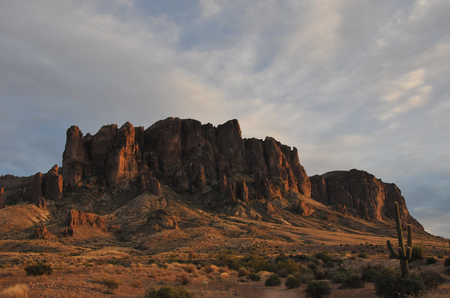
For years, I’ve been hiking on the edge of the Superstitions just outside suburban Apache Junction in a place called Lost Dutchman State Park. The park’s iconographic volcanic red rock spires jumble and congeal into 5,036-foot-high Superstition Mountain, nicknamed “The Flatiron” for its stepped ridgeline. Visible for miles, people instantly think of the Flatiron when they think of the Superstition Mountains. A gentle three-mile loop in the park leads you up toward the soaring cathedral spires of the Flatiron. As you look heavenward, up the ravines of the edifice, and hear the caw of ravens echoing off the rock walls, you no longer hear the cacophony of the suburban metropolis right outside the park. The loop trail here is a good workout and gives up spectacular views looking eastward across the wilderness toward the Four Peaks of the amethyst-rich Mazatlan Mountains. Turning to the west, it overlooks the Valley of the Sun all the way to the skyscrapers of downtown Phoenix, 40 miles distant.

Ray Gaff tackles a trail
I’ve often hiked the more difficult Peralta Canyon Trail on the south end of the “Supes,” a rocky 1,300-foot incline up to Fremont Saddle. You start up the canyon by crisscrossing the Peralta Creek, which originally was known as Willow Creek. As you rise up the canyon, you pass balancing boulders, and silhouetted hoodoos line the tops of the canyon walls like ancient soldiers. After crossing a lichen-patched granite field, you rise up over the ridge of Fremont Saddle and are smacked in the face by a stunning bird’s-eye view of Weaver’s Needle, a soaring monolith that rises more than 4,500 feet above the valley below. Here on the saddle, you pause and unpack your lunch, before heading a quarter-mile or so out to an overlook where ravens catch the thermals and soar past the needle, which is framed picture-postcard perfect by the boughs of a lone bristlecone pine.
On weekends, due to their proximity to metropolitan Phoenix, hiking Peralta Trail and Lost Dutchman Park with their crushes of humanity, is like trying to take a quiet hike in the middle of Central Park on the first warm spring Sunday. I’ve always wanted to go beyond and do more than these two trails, to go farther away from the crowds and deeper into the vistas I gazed down upon from Fremont Saddle. For years, Ray only whetted my appetite by showing me pictures of his hiking group, “The Fearsome Five,” and exotic views of their treks into the far wilderness area, which is part of the Tonto National Forest.
In fact, it was a Tonto forest ranger who gave the group their name 20 years ago. At one point the group grew to six, but stuck to their nickname. Today, Ray and Bruno are the only two of the group left. The others have either passed away or are unable to hike; age takes its toll on the knees, hips and ticker. “At one point, I guess, we’d all had some kinda’ heart surgery or bypass, so we started calling ourselves ‘the Cardiac Kids,’” recalls Ray, who himself has had several stents installed in his chest. I really think Ray and Bruno wanted to ensure that new blood knew about their favorite hikes before it’s too late. I had a flexible schedule, so this was the winter to hit the trail with my two retired friends.
Two weeks before the Tuesday morning that Ray and I headed out, Bruno had stepped into a hole on a trail, grabbed hold of a large rock as he fell, which rolled onto him. He was shaken by the fall, but the worst of it was the gash on the underside of his hiking stick hand. At 91, the skin can tear like parchment, and Bruno’s deep gash ended up needing eight stitches. As it was, he and Ray were nearly three miles from the trailhead. Ray, always well equipped, applied a tourniquet which stanched the bleeding. He hoisted Bruno’s pack and down toward the trailhead they went. “That fall shook Bruno up pretty good,” Ray recalls. “A couple on horseback came by and Bruno could have hitched a ride with them. But he’s stubborn—he wouldn’t hear of that.” So, they tramped on out and drove straight to the emergency room. Because the cut was on his hiking stick hand, the doctor instructed Bruno to take a couple weeks off the trail to let things heal up.
On our own, with Bruno on hiatus, Ray and I drove up scenic Highway 88 into the heart of the Superstitions as the sun began to peak over the wilderness. It turns out our destination was a real bush hike—a trail through the desert brush that Ray and the gang had created themselves, marking the “trail” by setting cairns (small rock pyramids) every few yards. “We’ve decided to call this ‘No-Name Trail,’” Ray informed me as we hacked our way from cairn to cairn in the thickest underbrush. In places I lost complete track of the cairns, though Ray could spot them two hundred yards away—after all, he’d built them.
“ ‘No-Name Trail,’ huh?” I grunted as we climbed the steep ridge face. “Ray, there is no trail.”
He smiled as if that were just the point. No-Name Trail was the Fearless Five’s top secret, a creation of their own, their private legacy to the land of the Lost Dutchman. I had the distinct feeling that on this day, it may well have become my legacy to carry on. I’m sure that’s why Ray brought me here. My only regret in taking on this mantle is that I don’t have a GPS coordinate for each cairn.
The trailhead, really the start of a goat trail, was at an abandoned mine site a few yards west of Highway 88. The trail started below a jumble of broken limestone rocks, scattered with spent shot gun shells and beer cans. After a half mile the trail broke open into a wide verdant valley of mesquite, paloverde and catclaw where we crossed a dry wash across the valley to a small rock canyon draw where we came upon the first cairn. We battled up through the brambles and arrived at a prospect overlooking the little valley we had just crossed. Here we were in a forest of cholla cacti and the ridge face in front of us, which rose some 1,500 feet to the top, was covered with a forest of cholla, saguaro and ocotillo. As we picked our way slowly from cairn to cairn, Ray hacked away at the cacti with his hiking stick, and with leather-gloved hands pruned the catclaw to open the trail. Here and there he restacked cairns that had toppled. An 81-year-old man is beyond barreling up a hillside trail just to take in the vista. The pleasure in hiking for both Ray and Bruno is in tending the trail, making repairs, looking at rocks and essentially picking their way and enjoying the journey to the top.
Two hours from the trailhead, Ray and I topped the ridge and followed more cairns to the largest king cairn that crowned the very peak of the hill. Ray silently leaned on his hiking stick with gloved hands waiting for my reaction. My reaction was, “Good god, look at this view!”
“Yup,” chuckled Ray with his gravelly Indiana drawl. “To me, this is a better view than from the top of the Flatiron.” Indeed, I must agree, even though I’ve never been to the top of the Flatiron. From No-Name Ridge you have a 360-degree mountain view of the Superstition Wilderness, and from here you are looking straight at the Flatiron to your south. To the southeast, you see Weaver’s Needle. To the northeast, you look down on Canyon Lake above which rises in the distance the 7,600 foot-high Four Peaks. Way to the north, you see the Mogollon Rim, and to the west you can make out Saguaro Lake and below that the 562-foot-high spout of the gushing fountain of Fountain Hills.
“When we brought the ranger up here, he said he thought it was the best view of the Superstitions he’s ever seen,” nodded Ray, gazing off to the jumble of volcanic mountains to the east. “I’d rather spend a day out here, than four hours on a golf course. Some people just don’t understand that.”
The Superstition Mountains Wilderness Area, established in 1939, covers about 160,000 acres (250 square miles) of central Arizona south and east of Highway 88, which is also known as the Apache Trail Historic Road, and meanders along the Salt River past Canyon and Apache Lakes, up through the tourist town of Tortilla Flats, to the Roosevelt Dam.
Igneous red rock from the cauldron of time defines this rugged landscape with elevations ranging from 2,000 to over 6,000 feet. Superstition Mountain tops out at 5,036 feet, while Weaver’s Needle, which many geologists now believe is an erosional outcrop rather than a volcanic plug, majestically rises to just over 4,500 feet from its valley floor. While volcanic activity formed the mountains and shaped the mesas, erosion formed the crevices, ravines and canyons. Poet and essayist Gary Snyder might include the Superstitions in a description from his essay collection, A Place in Space, of ‘natural nations,’ natural communities, which have been “shaped by mountain ranges, river courses, flatlands, and wetlands.”
This is the High Sonoran Desert with its signature cacti—saguaro, cholla, ocotillo, prickly pear—and paloverde, mesquite and catclaw trees. Ponderosa pine forests, “sky islands,” blanket the highest elevations. The wilderness area features about 180 miles of maintained trails, and Ray and Bruno have maintained a good many of those miles for decades.
As Snyder points out, some may wonder what good this wilderness is to civilization? After all, by one definition, he notes, wilderness is wasteland, an area unused or useless for agriculture or pasture—though more than one rancher has tried to make it in the Superstitions during the past century. Remnants of ghost ranches are still hiking landmarks and destination campsites here. Another definition of wilderness that Snyder presents in his essay, The Etiquette of Freedom, is particularly apt for the Superstitions: “A place of danger and difficulty—where you take your own chances, depend on your own skills, and do not count on rescue.”
The lure of a Mother Lode of gold has brought many a prospector down these treacherous trails since the early 1800s—to great disappointment and tragedy. The Lost Dutchman Gold Mine is the most famous in lore, though it’s a question whether such a thing ever did exist. The Dutchman was actually a German (Deutsch) gold prospector named Jacob Walz, who homesteaded in 1868, on the northwest edge of what would become the wilderness area. Photographs of Walz depict the quintessential pioneer prospector with wild eyes and flowing white shaggy beard. Lured into the mountains by stories from the local Apache tribe of vast mineral deposits, primarily gold, Walz ended up working in other commercial mines while prospecting the Superstitions for his own mine.
While working at the commercial Vulture Mine, Walz befriended another German employee, Jacob Weiser, with tales of the legendary gold of the Superstitions. The two up and left their jobs at Vulture and set out on their search. Many believe the two took off with a substantial bounty of Vulture gold when they left.
Regardless of which version of the story you hear, in a nutshell, the two men allegedly found a lost mine in the Superstitions full of gold. Periodically they would return to the Phoenix area with tales of the mine, spending the gold nuggets that many assumed they had stolen from the Vulture Mine. Giving contradictory directions as to the location of the mine, the two Germans used their knowledge of the mountainous terrain to outrun their pursuing competitors.
Well, according to legend, Weiser disappeared, and many suspect Walz of killing the man. Walz died in 1891, never disclosing the exact location of his alleged mine. Ever since, to no avail, people have searched the Superstitions high and low for The Lost Dutchman Mine.
For the native Apache, Superstition Mountain with its flatiron profile, was a sacred and mysterious mountain where many men perished. When the Spanish conquistadors arrived searching for gold, the Apaches assured them there was gold up in those hills. But when the conquistadors started to explore the mountains, their men began to mysteriously disappear—those who were found were found mutilated, many with their heads cut off. In terror, the conquistadors refused to return to the mountains, which they began to call “Monte Superstition.”
Only three mines in the Goldfield area on the northwest edge of the designated wilderness area—Mammoth Mine, Bull Dog Mine and Black Queen Mine—ever produced significant amounts of gold ore. Other mineral deposits, such as silver and copper are here, as well, but the veins are situated so deep that no commercial mining operation in more than a hundred years has taken a serious stab at it. Since its establishment as a wilderness area in 1939, the area has been virtually off limits to any commercial mining concern.
A week after our “No Name” trek, Ray and I pick up Bruno at 7:30 on an unseasonably warm Tuesday morning. Bruno is the type of senior citizen who bolts out of bed at 5:00, listens to the news, devours the newspaper over breakfast, and by 7 a.m. is stalking the neighborhood looking for a target to talk with. On first jaunty greeting, I know I’m in the company of an extraordinary specimen of a 91-year-old man.
He’s been anticipating our arrival, with sturdy German hiking boots and hiking hat on, and waves us in with his thickly bandaged hand. He’s already signed off for the day with the neighbor lady who keeps tabs on him.
As Ray steers us through Apache Junction toward Highway 88, Bruno warns, “We’ll have to take it easy today, Ray. I’ve been off the trail for three weeks.”
He dismisses his injury as that “damned hand,” but admits the cut has been a bugger to heal. The calloused skin on the inside of the hand has been stubborn to pull together. After months of steady hiking, he fears his legs have atrophied during his three-week layoff.
Bruno is buoyant as we head into the Superstitions, relieved to be back in his element, chattering away with Ray, his accent hinting at his youth as hiker in New Hampshire’s White Mountain range. Each curve of the road reminds him of hikes past. “Ray, we need to take young Tom here (‘hee-ya’) up Black Mesa. Say, We need to show him that old mine!”
“Which mine?” says Ray.
“You know, Ray! Our mine! The one out there (‘thay-a’) by Pickett Post.”
“Tom,” he asks, “Have you ever crossed the Flatiron?” Bruno waves toward Superstition Mountain. I sense his disappointment when I tell him no. He claps me on the shoulder and says, “Well, dammit, Ray! We’ve gotta’ get him up thay-a!”
We’re now approaching “No Name Ridge,” which I now can recognize as readily as Weaver’s Needle from miles away. In fact, after reviewing a recent photo shoot shoot, I realize that several weeks earlier I had unwittingly framed “No Name” with my telephoto lens as the centerpiece of a landscape I shot from Lost Dutchman State Park.
“So you were up there last week, eh?” Bruno asks us. “How are our cairns holding up, Ray?”
“No Name Trail?” I say.
“Hell, we’re callin’ it the Ray Gaff Trail from now on,” chuckles Bruno patting Ray on the shoulder from the backseat.
Bruno Baldacci grew up hiking and skiing the mountains of New England. He served in the ski patrol during World War II. After a long career as a manufacturing businessman in flatland places like Peoria, Ill., and Cleveland, Ohio, he and his wife retired to summers at a cabin in the Adirondacks and winters in Arizona. Widowed several years ago, Bruno still splits his time between Cleveland, the Adirondacks and the Superstitions. Last year was the first time he didn’t make the cross-country drive to Arizona by himself. His children insisted he fly out west instead—a concession he is still grumbling about.
The Adirondacks have 46 peaks higher than 4,000 feet. If you record your hikes up each peak, you become a member of an elite club called the Adirondack Forty-Sixers. Bruno is a proud member, having recorded his first hike up Rocky Peak in July of 1995 and his final peak, Marcy Peak, in August of 1997. He, Ray, and the Fearless Five, joined forces in Arizona in 1989.
We leave the Boulder Canyon trailhead at the Canyon Lake marina and make our way up the first ridge. We pause to catch our breath and take in the breathtaking panorama of Canyon Lake below. “Ray and I have hiked together now for more than 20 years, Tom, and never once have we had an argument. Not one argument! Oh, heck yeah, we’ve had our disagreements on a few things…but we’ve never argued.”
As Ray points out a distant landmark, Bruno squints into the morning sun and shakes his head. “Damn, my eyesight ain’t what it used to be! I can’t see anything at a distance. Ray, you’ve got good eyes.” Every now and then when a recollected name is slow to come, Bruno laments what he feels is a loss of memory. At 91, there are a lot of names, a lot of memories, to sort through.
What comes to his mind most often are the people he and the gang have met on the trail—and the lost hikers for whom they have helped the rangers search.
“I call ‘em ‘flatlanders,’” he explains. “You can spot ’em a hundred yards away. They don’t have a clue about the kind of terrain they’re in.”
We’re high on a precipice now looking deep down into LaBarge Canyon. “You look at that mountain over there and it looks so benign. But, let me tell you, Tom,’ (he waves his hiking stick across the wide horizon), You start hiking up it and I guarantee there’s nothing benign about it.”
Through the years, he and Ray have helped search for a score of lost hikers—some of whom were never found. The Superstitions grudgingly give up their lost. From the earliest prospectors to today’s GPS-equipped, designer-clad hikers, the Superstitions hold secret the mysteries of the dead.
In fact, in just the last two months, Ray and Bruno have been on the lookout for two flatlanders reported lost in the wilderness area. They believe they may have come very close to them, but it wasn’t until several weeks later that the hikers’ decomposed, vulture-scavenged bodies were discovered by others.
“These mountains may look parched and dry, but I tell you, there’s water out there if you know where to look. There’s springs all throughout here,” Bruno says, sweeping his stick across the rugged horizon. Bruno tells me, for the first of several times, about an encounter he had years ago with a couple of young hikers.
“I hate it when flatlanders come up to me on the trail and ask for directions or advice. I feel too responsible for them! These two young ladies came up to me with their dog on the First Water Trail. It was late in the afternoon and the sun was going to be setting soon. They had on sneakers and a bottle of water between them, maybe some sun lotion. They wanted to know the way to Black Mesa, which was miles away. I explained that to them and advised them to turn around and hike out with me. ‘Try it another day,’ I told ’em. ‘It’s gonna’ be dark soon.’ But no. They insisted on hiking. So I left ’em. I felt guilty about it, but I let ’em go on.”
“Well, sure enough, the next day I’m watching the news and they’re talking about how rescuers had just brought these two young girls out of the Superstitions after spending a night out there! It happens all the time. Flatlanders, I call ’em!”
Once we reach the overlook of LaBarge Canyon we turn around for the return trip. We’ll have done about seven miles by the time we reach the trailhead—enough for a recuperating Bruno and, frankly, more than enough for me. Ray, on the other hand, could go another 10 miles or more.
Bruno’s bandage is spotted crimson by blood, his wound has opened as he switched his hiking stick from hand to hand. “Dammit,” he says. “I guess I’ll have to stick with the other hand. It puts me off kilter, but here we go.” As it is, he’s held up well for his first hike in three weeks. He stumbled on scree only once, but that’s something we all do. With a flick of his hiking stick, he knocks the offending stone off the trail. “That’s their punishment for trying to trip you up,” he laughs.
During a checkup a few days after the initial stitiches, Bruno asked the nurse when he might return to the trail. She advised him to wait a few weeks: “What are you trying to do? Kill yourself out there?” she said.
“Hell yes,” Bruno replied. “Why not? I’ve outlived the average life expectancy. My wife is dead. My kids are just waiting on their inheritance. I tell everybody, if I’m lost out here, don’t come looking! I’m exactly where I want to be!”
As we near the Canyon Lake trailhead, I think that this isn’t really quite true. It’s just more of Bruno’s volcanic bluster. Would the old man really prefer to die of thirst and starvation deep in a canyon below these sun burnt hills?
Though I’m sure there was thread of credibility to what he was blustering on about, the fact is, it simply wouldn’t happen. In the unlikely event that Bruno could get lost in this wilderness that he knows like the back of his blood-stained hand, then Ray, I and the rangers would hike high and low through the Superstitions. We’d search hard and long to recover the legend, and the legacy, of our dear friend, Crazy Bruno.
Sojourn Stats
• One of the best ways to begin your exploration of the Superstition Mountains is to visit Lost Dutchman State Park, located on SR 88 about 15 miles east of Apache Junction/U.S. Highway 60. Park entrance fee is $7.00 per vehicle. Camping sites and new cabins are available. Check the website for details, as well as maps of the trails which range from fairly easy to difficult. Link to Lost Dutchman State Park via azstateparks.com.
• The Peralta Trail on the south side of the Flat Iron and the Superstitions, is a moderate climb up to Fremont Saddle and a panoramic view of Weaver’s Needle and the Superstition Wilderness. The Peralta trailhead is about 10 miles east of U.S. Highway 60 near the development of Gold Canyon.